Objective
To learn to use Adobe Illustrator tools
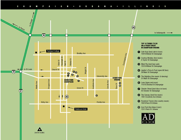
by example. To learn design principles by recreating the map below:
Discussion
Out-of-town judges from major ad agencies were invited by the now-defunct Ad Club of Champaign-Urbana to judge a local awards show. The judges arrived on Friday night and were promised an evening of fun and entertainment before the work began on Saturday.
This map was created to give the judges an overview of our Champaign-Urbana and where the best entertainment is located. Only key information has been included. Any non-essential information has been edited out. The result is visual simplicity that is unified by repeating elements. Abstraction, distortion and exaggeration of scale are used deliberately to achieve clarity.
Procedure
Prepping for the exercise
- download starter files
- examine downloaded files
- turn on "Carta" using Fontbook
- launch Illustrator
- file > new (CMYK, letter, landscape); save as "champaign.ai"
- practice Illustrator navigation shortcuts (space=hand, space+cmd=zoom
in, space+cmd+opt= zoom out; cmd zero=fit in window)
- Illustrator > preferences: general: scale strokes & effects=no
- expand dock
- Google a reference map of Champaign; make screenshot
- file > place "picture 1.png"; scale image to fit page
- make "layer 1" a template layer (double-click)
Drawing the map
- new layer "bg"
- draw box, fill with bg color
- draw box for city boundaries, fill with yellow
- new layer "streets" (lock other layers)
- pen tool: stroke=white, weight=3pt
- draw major streets
- new layer "interstates"
- pen tool: stroke=green, weight=4pt
- draw highways
- object > path > outline stroke
- swap stroke/fill (stroke weight=3pt)
- adjust scale and distance to fit page (direct select tool)
- new layer "symbols"
- type tool: add point type (font=Carta)
- window > glyphs: double-click interstate symbol
- scale and position symbols
- draw squares for interchanges (fill=white, stroke=1pt)
- draw circles for major highways
Adding labels
- new layer "labels"
- add black squares for major landmarks
- add black box to label major landmarks
- add black box for title
- add arrows (filter > stylize > add arrows)
- new layer "type"
- copy and paste text from "map.txt" into Illustrator (8pt Helvetica Cond Medium or Black)
- position type for streets
- add numbers (font=Zapf Dingbats)
- new layer "type white"
- position white type for labels, title
Finishing the map
- add triangle to "symbol" layer (rotate square 45°, delete bottom anchor)
- copy and paste logo from "ad.club.logo.ai"
- new layer "mask"
- draw white boxes to cover up non-printing art
- adjust layout as needed
- save, print
Grading
- add your name to the bottom of the file
- file > save for web: preset=GIF 32 no dither, image size=800px wide
- publish GIF as a link from your projects page
- submit a color laser proof with your
name on it for grading
- file graded proof in your 3-ring binder for individual review